Thursday, May 3, 2012

Challenger Point and Kit Carson Peak 4/24/2012

Total Mileage: about 13 miles
Total Elevation Gained: about 6300 feet
Starting Point: Willow Creek Trailhead
Party: solo
Time: 12.5 hours

Challenger Point and Kit Carson Peak right before sunset from the road out.
I started this trip with the intention of spending two days hiking while my wife and daughter were out of town and I had work off. I left Colorado Springs around 3:15am and was making great time to the first trailhead on my list. At around 5:00 am I was about 2 miles west of Salida, CO when a deer decided to jump in front of my car. I will tell you that the deer was pregnant. I will not tell you how I know that. Suffice it to say that my car sustained some significant damage that would limit my adventure to one day only. I would need to use my extra day off to report the claim to my insurance and deliver my vehicle to begin repairing it.

Not the best photo but this was at the trailhead as I started off.
Once I discovered my car to be operable I thought it senseless to not continue with my plans for the day. The only internal damage done was a leak to the power steering fluid. It was a beautiful morning contrasted by a very rough start. I arrived at the trailhead and made my preparations to begin.

First light on the mountains. The red dot indicates my first destination. The headwall that leads to Willow Lake.
So pensive!

A clearer view of the headwall with the red dot marking the same place as the previous picture

In light of the early morning's events I found it eery that I have never seen more deer on a hike than this day.

Getting closer to the headwall which is at about 11,300 feet and a mile and a half or so from where this was taken. 
I didn't really encounter any snow until I reached the headwall. And even then it was not significant until well above 12,000 feet. I had my snowshoes with me but never used them. I never found it necessary. I felt like I was pretty speedy up until this point. My tendency is to go too fast initially I think. I find myself hiking about 2 miles per hour under 12,000 feet and slowing to about 1 mile per hour above.

I finally reached the headwall and started to get some the sun that was previously blocked.

My car is parked about 1.5 miles past the clearing you see. This was taken at the headwall previously shown. 

Just above the headwall where snow began to be more significant. Looking back.
The snow covered the exact trail for a bit but I quickly picked it up again. Willow Lake is about 3/4 mile from the top of the headwall and I felt like it went quickly. If you like waterfalls then this hike is for you. There were a lot of them.

Willow Lake is just above this waterfall.

First glimpse of the Lake through the trees. Frozen waterfalls trying their best to stay that way.

Coolest lake I've ever been to in the alpine. The route takes you on top of the cliffs you see bordering the far end of the lake. 

So awesome.

From the top of the cliffs I was able to take a long break. I ditched my snowshoes and found the stream dumping into Willow Lake. I purified 2 liters of water and began to think about the next part of this hike. I decided to leave my pack behind to make it easier on myself. I brought a liter of water and filled my cargo pockets with fruit snacks, energy gu, and my cell phone and wallet. I put on my microspikes and some gloves and headed up. A parting shot of the lake.

I threw a rock. The ice didn't break.

Kit Carson Peak 14,165 feet.
All I will say is that the hike up to Challenger (not visible above) was very tough. The snow was a bit unstable and good traction was hard to come by. It took me 3.5 hours to get to where I dropped my pack. It would be 5.5 hours until I would be back at my pack. I took frequent breaks and began to realize I needed to ration my water. I reached the top of a notch which was about 13,900 feet and could finally see Challenger and Kit Carson together.

Challenger on the right and Kit Carson on left.

Taken from the summit of Challenger.

Challenger Point 14,081 feet! Crestone Peak in the distance.
The above picture was taken in the only direction where blue sky was visible. It seemed to be raining in every direction and location except where I was. So I didn't stay on Challenger very long. I stayed on top for maybe 5 minutes and I was off to get Kit Carson Peak next. I would need to drop 200 feet, climb 100, drop another 200 and finally climb the final 400 feet to get to the top. The route follows a ledge system that is commonly referred to as Kit Carson Avenue. At this time of year that ledge system retains a bit of snow and ice on it. Makes it a little more technical but I never felt unsafe in the least bit.

Coming down Challenger this is the beginning portion of The Avenue.
From the Avenue looking back on Challenger. A human can be seen on top of Challenger. 

The snow got steep in some places and sometimes I had to travel just below the Avenue to find solid rock. About 90 minutes after topping out on Challenger I reached the top of Kit Carson Peak.

2nd summit of the day!

Humboldt Peak on far left and Crestone Peak and Crestone Needle on far right. 

Looking back down on Challenger Point

Looking way down to Willow Lake and figuring out how to get back down there. The frozen waterfalls are barely visible.
 The way down turned out to be quick and easy. I didn't have my ice axe with me so I didn't feel good about glissading without a way to self arrest. From the saddle between Challenger and Kit Carson I plunged stepped through the snow down the Kirk Couloir. This a narrow chute that would lead me back to Willow Lake. It was pretty steep but the snow was perfect for it. At times the plunge stepping would evolve to short glissades that I would stand up from pretty quickly to resume the plunge stepping once again.

Before I knew it I was back at Willow Lake and reunited with my backpack and stashed snowshoes. I took some time to filter some water from the stream and packed up to head on out. The way out was pretty clear with the trail disappearing at moments from the remaining snow. I always picked it up again shortly. I ran into some campers just below Willow Lake. Chatted with them for about 5 minutes and I wouldn't stop again until the car about 4 miles down trail from the lake.

My prayers were answered when my car started up just fine and was mechanically sound. Minus the power steering which was an annoyance but an acceptable loss all in all. The damage to my car would be about 6K and 1 week in the shop to repair. Luckily, insurance companies consider this like an act-of-God and all I had to pay was my $500 deductible plus the cost of a rental for a week (about $100). Given the days events, a second day of hiking would have to be passed up. Still a great hike and a beautiful area to have explored.

Sunday, March 25, 2012

Ellingwood Point 3/22/12

Total Mileage: 9.5 miles
Total Elevation Gained: ~4000 ft.
Starting Point: Lake Como Approach
Party: myself and Curt (mtnsurveyer on 14ers.com)

Ellingwood Point 14,042 feet
The weather was forecasted to be working in our favor today as we set off for the Sangre de Cristo mountain range. The Lake Como approach grants access to three 14,000 ft. peaks. This would be my third venture to Lake Como to bag the third and final 14er that this approach allows access to. It was one year ago, nearly to the day, that I had first slogged my way up the lousy Lake Como road to tackle Little Bear Peak. When summer came around I headed back for a shorter day trip anticipating a summit of Blanca and Ellingwood. Once atop Blanca I could see foreboding clouds that warned against an Ellingwood summit. Today my eyes were set on Ellingwood and Ellingwood only. My climbing partner Curt wanted both peaks but that wasn't a priority for me. As it would turn out, he was very capable of finishing two peaks in the time it took me to do just one. 

We were able to drive to 10,300 feet up the Lake Como Road where I parked my Jeep. We readied our packs and set off around 6:30am. We were about 2.25 miles from Lake Como and arrived there quickly. Along the way we enjoyed the views of the valley below and the wildlife around us. 

Taken around 11,000 feet.

Always fun to see one of these guys.
 Upon arrival at Lake Como (~11,800) we donned snowshoes and they wouldn't come off until about 13,300 feet. We crossed right over the lake and into the trees beyond.

My first time walking over a frozen lake ever!

Curt making his way across with Little Bear Peak looming.

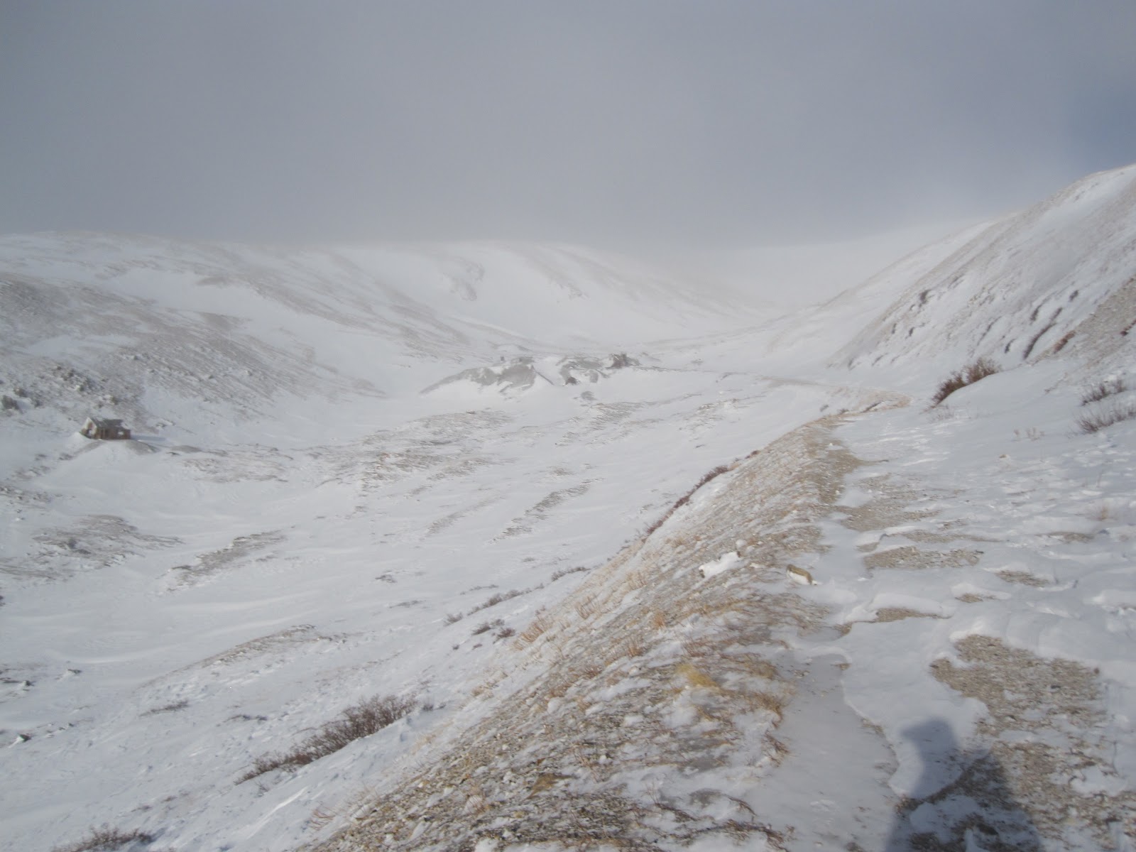
Beyond the lake the snow deepened for short while.
We were lucky to be able to follow some tracks of a lone hiker ahead of us. With our tracks added to his a nice trench was forming nicely. We would find out later that those tracks belonged to Ken Nolan, a local CO mountaineer with over 1800 summits under his belt and I believe over 500 14er summits. I understand he is trying to complete what is known as "the grid." For those unaware, the grid constitutes the completion of all 14ers during every month of the year. To complete "the grid" for one peak requires 12 individual summits of that peak during each calendar month. Completing this for all 14ers in CO (58) would require 696 unique summits. Not one of my personal goals but I can see how one might get wrapped up in this. 

So, on through the trees we continued and soon we caught our first glimpse Ellingwood Point.

Zoomed in version of the first picture. 
Before too long we emerged from the trees to beautiful blue skies. 

Curt leading the way
It became very clear at this point that Curt's speed was far greater than my own. The distance between us became greater and greater. We finally saw in view the lone hiker whose tracks we had been following. This seemed to motivate Curt to speed his pace to catch up which he promptly did. Before leaving me in the dust we discussed that he should go onto Blanca and that I would only be climbing Ellingwood and we would meet back at Lake Como. The way the two mountains are situated allows for one to constantly view the other. So we remained within eyesight almost the entire time. 

Curt leaving me in his dust. 
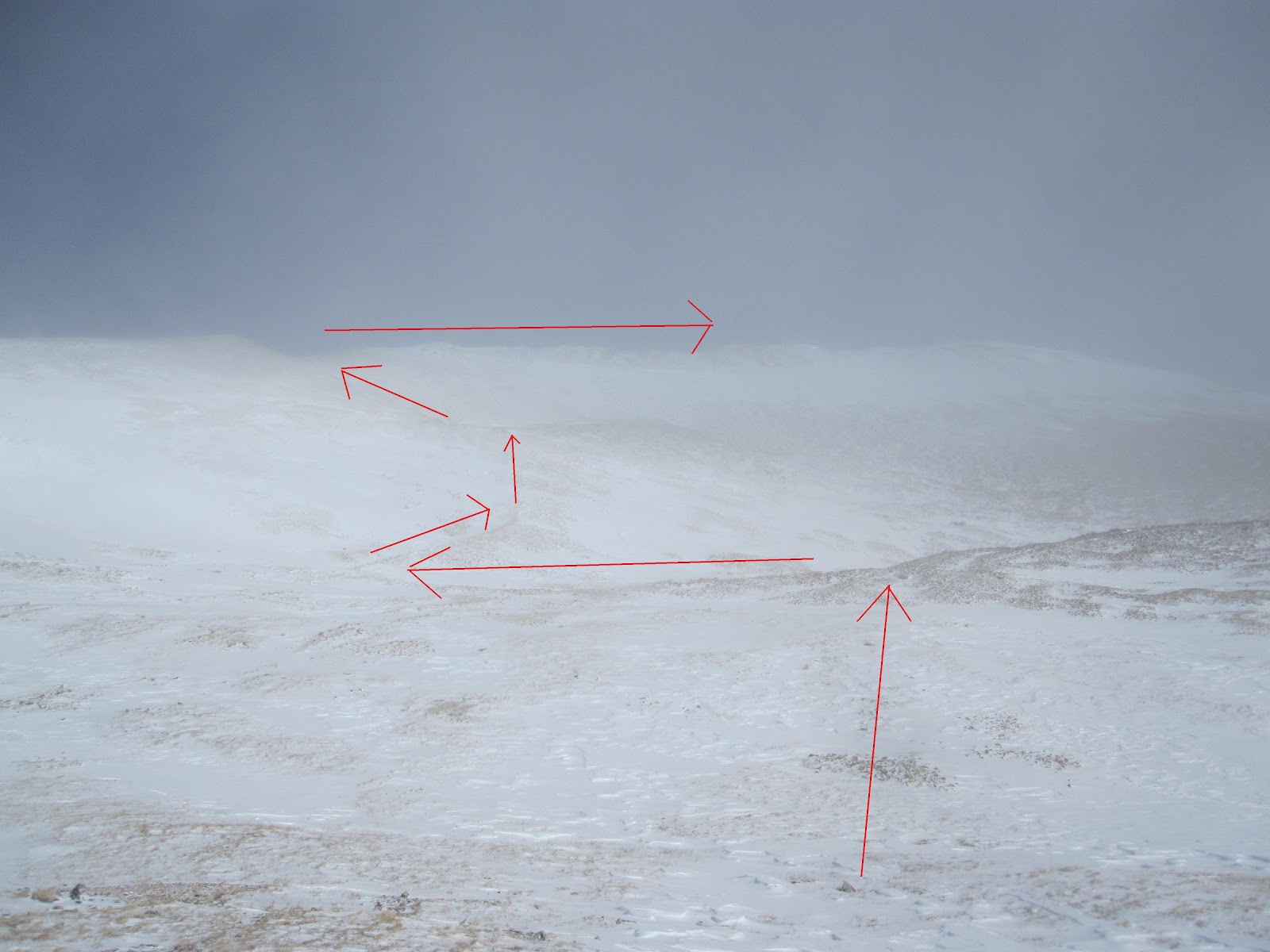
In the picture above are a series of ledges that need to be overcome. The top of which sits at about 13,300. Once I reached the top I ditched my snowshoes. I could see Curt had caught up with Ken ahead of us and they were both about 400-500 vertical feet above me. It was at this point that I made a miscalculation that cost me about an hour of wallowing in slush. The route forks at a certain point and I had waited too long to veer left for Ellingwood. At about 13,600 feet I realized this mistake and the result would require me to lose about 100 feet of elevation to get myself on the right path. I suppose the silver lining was that I was able to scout out a good route for the ascent up the south face of Ellingwood.

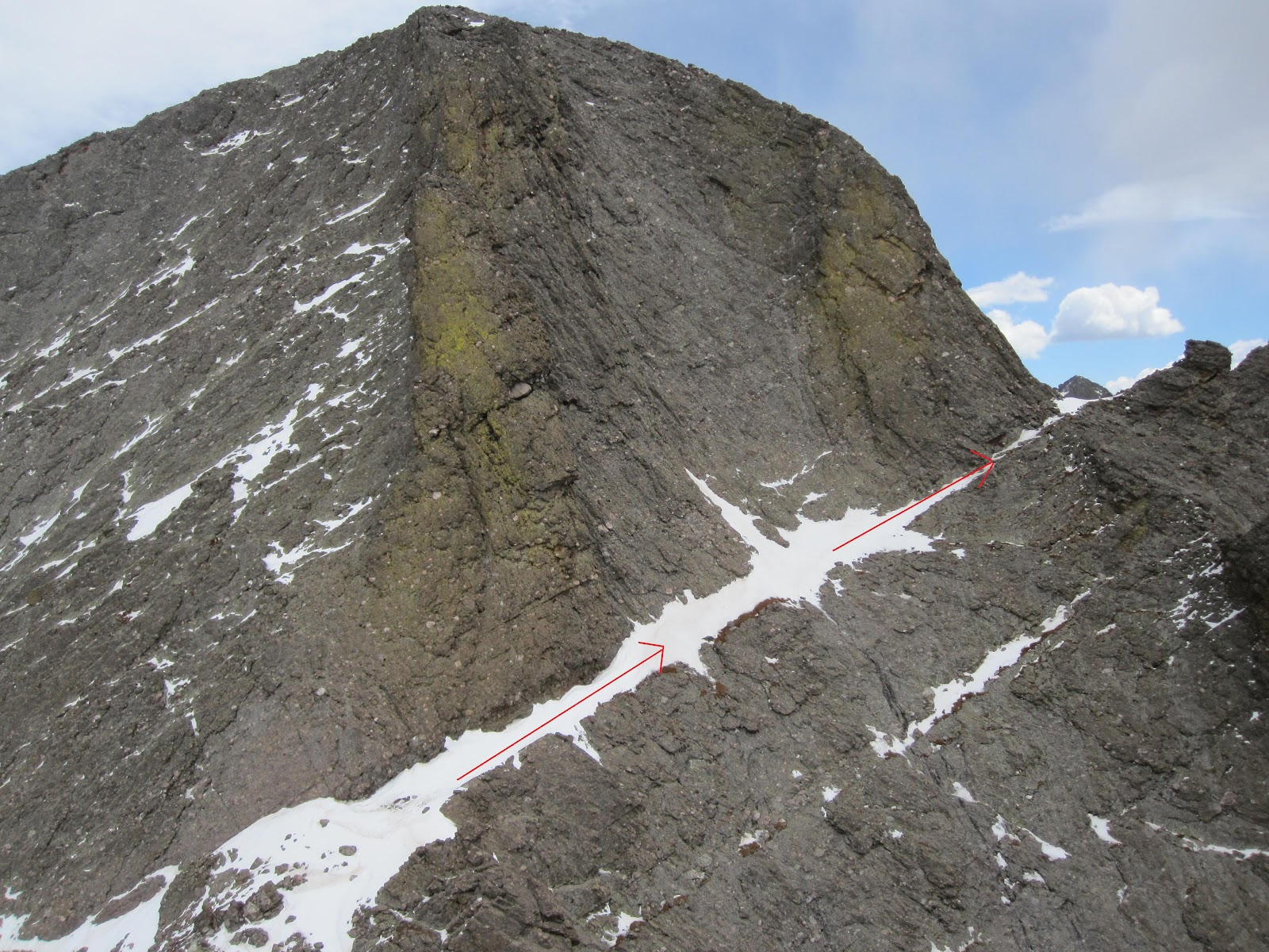
South face of Ellingwood and my general route up.

From further up the correct route one can see my course correction.

From almost near the summit and zoomed in you can see my tracks emerge from the rocks and then suddenly drop and intersect Ken's tracks from earlier in the day. 
From a lower elevation this shows the same thing. 

Upon making my course correction it didn't seem like it took me long at all. The temperature was getting much warmer and I got down to my base layer. I kept glove liners on and a beanie for sun protection. However, I left my eyes exposed and I would pay the cost later. I had sunglasses in my backpack but when I tried to retrieve them I found the frames bent and the lenses dislodged from the frames. I had left my ski goggles in the car due to the mild winds forecasted. I had no idea at the time what lied in store for me that night.

As I climbed up onto the ridge the views were astounding. I only had about 200 vertical feet to hit the summit and I felt great. I heard a voice from behind me and it was Curt. He hadn't descended Blanca like I thought he would but instead he traversed the jagged and very snow-covered saddle. A little spicy for my taste but everyone has their own comfort level. I took my time and reached the summit about 10 minutes before he did. We took some time to enjoy ourselves and got our summit pictures and headed back down after about 20 minutes. 

On the ridge but the true summit is not in view.

Curt making the final push with Mt. Lindsay behind him.

Curt on the summit with the Crestones in the background.
Here I am on the summit with Blanca Peak behind me.

Little Bear Peak on the left.

Heading down from the summit behind me.

Last look at Ellingwood as the day drew to a close.
We were back at the car at around 5pm. I'm a slow hiker anyway, but this was a slow day even by my standards. It took about 45 minutes to drive the 4 miles down Lake Como road and about 2.5 hours later I was home. 

Once home, my wife told me my eyes looked bloodshot and I knew I had got a lot of sun. I applied sunscreen liberally at three different times along the route and even remembered my SPF 30 lip balm. I went to bed at around 9:30 pm and realized that I was uncomfortable. My eyes were watering and it was hard to keep them shut. I just tried to doze off and forget about it. I awoke at 10:30pm in more pain then I can remember ever being in. Like there was sand in my eyes I couldn't flush out. In the back of my mind I knew snow blindness was probably what was happening. I had my wife do a quick google search and it matched my symptoms exactly. The corneas of my eyes had been sunburned. My wife ran to the store to buy eyedrops that did no good. Nothing relieved my pain. I decided to sleep in the front room as to not disturb my wife and just try and get through it. Snow blindness, in most cases, does no permanent damage and a complete recovery is expected within 48 hours. I spent the next day laid up in the darkest room in my house wearing sunglasses and trying to sleep away the day. Now, almost 72 hours later I feel virtually no symptoms and a valuable lesson has been learned. I'm grateful to a wife that knew how to pamper me through such a roller-coaster experience. She brought me food and water and would often just sit with me in the dark and occupy my mind with small talk. 

I suppose that it is experiences like these that fortify our resolve to be better prepared for future events.  I am confident that I will never experience this again and hope that hiking enthusiasts reading this may benefit from my mistakes. 

Saturday, February 25, 2012

Mount Sherman 2/2/2012

Total Mileage: ~10 miles
Elevation gained: ~3000 feet
Party: solo
Starting point: .75 miles before the Leavick site

Mount Sherman 14,036 feet (summit not visible) 
It was time to get out again. The forecast wasn't ideal but it rarely is this time of year here. It was about 5:30 am when I arrived at the trailhead. No other cars had arrived before me so I had no idea who I might be sharing this mountain with today. I got suited up and headed up the snowdrifted road. I may have been able to  get another .5 miles up the road but better judgement got the better of me. The snow was about 8-10 inches deep where I stopped. It didn't take long before I donned my snowshoes. Made such a huge difference in energy expenditure.

There's a lot of people who claim Sherman as one of the most boring 14ers in all Colorado. I think it helps to climb it in winter covered in 1-2 feet of snow. It really was awesome and quite challenging for me. I made it to the Leavick site fairly quickly which is the normal summer trailhead for most people.

This area is rich with mining history.  That's the extent of my knowledge though.

A lot of signs warning to keep out. Might be a secret fight club location.
About a mile in it became light enough to turn off my headlamp. The sun never really came out that day. It tried to all day but the fog cover just hovered in the wrong place all day long. It still was quite scenic but I would have loved some unobstructed views.

From the Leavick site it's just up and up the road. Passing what remains of a once thriving mining operation.

You can see the wind picking up here and the sun trying to get though creating a kind of eerie scene.

The mountain ahead of me covered in clouds.

Further up the road this is another look back. 

Mining stuff.

This is the Hilltop Mine at ~13,000 feet. The wind hit a fever pitch right as I topped out at the mine.

White Ridge 13,684 feet shares a saddle with Sherman
Well, everything was manageable until I hit the Hilltop Mine shown above. The standard route gains the southwest ridge of Sherman via a saddle connecting it to Mount Sheridan. The entire saddle was obstructed by a huge snow cornice essentially making it impassable. To add to the difficulty the wind was rip-roaring and tearing through the area just below the saddle. I had determined that I was done and had actually started to turn around. I made one last look to assess any other way up. I spotted a line that I thought might work. It was fairly steep but I thought I might be protected by the wind so I figured I'd give it a shot.

The basic route I took up vs.....


Here is Mount Sheridan and the massive cornice obstructing access to the saddle from below. 
As I gained further up my chosen route it become clear that I had made the right choice. It also protected me from the wind until I gained the ridge. The route I had chosen carried me to the southwest ridge at about 13,700 feet. Once there I had to face even stronger winds but only had about 400 vertical feet to climb before I could start climbing back down. It wasn't the strongest winds I have ever been in but it was consistent and relentless.

This is most of the remaining route from where I gained the southwest ridge. 
Very cool snow crystal formations on the rock at just under 14,000 feet.

I guess you'll just have to trust me that this is me and that I am standing on the summit. 
No views from the summit which is always a bit of a disappointment. I was glad to be at the top and I was glad to start descending. I had purchased some new OR gloves that were a huge improvement from my old ones. My hands still froze instantly when I removed my gloves to take some of these pictures. But they didn't stay frozen for long like they used to. Once off the ridge I began to warm up quickly and made good time getting off the mountain. I had my axe with me so I could enjoy a controlled slide down the mountain. I was able to slide down about 1000 vertical feet total. A huge break for the knees.

It took me about 5 hours to summit and just over two hours to get back to the car. There was another car parked next to mine when I arrived back. But I never saw a single soul the entire day. I had the whole mountain to myself.